
Metal-Based Minerals & Kimberlite Pipes: Any Terrain, Anywhere
VMF remote sensing provides an unparalleled solution for the direct identification of mineral deposits. Our technology accurately locates targeted minerals and determines the depth of ore bodies, extending down to several kilometers. Additionally, we create detailed deposit cross-sections and offer tailored recommendations for drilling programs, ensuring optimized exploration and resource extraction.
VMF can identify and map a wide range of mineral commodities, including:
Rapid Detection, Assessment, and Development of Mineral Deposits
In the fields of geology and mining, increasing time and resources are being spent on the prospecting and exploration of mineral deposits that are not exposed at the surface, often located in remote or difficult-to-reach areas, or buried beneath modern sediments. VMF technology enables the accelerated detection and accurate assessment of these deposits, achieving up to 98% accuracy, significantly improving exploration efficiency and resource management.
Stages of Research Using the VMF Methodology
Area Selection and Preliminary Study
Initial identification and evaluation of the target research area, based on geological and geospatial criteria.
Selection of High-Quality Satellite Data
Acquisition of high-resolution satellite imagery to ensure detailed and accurate analysis of the area of interest.
Processing of Digital Data
Advanced processing of digital data for specific elements, including spinor and multispectral analysis, along with specialized mathematical methods. This involves programming and computational processing of materials to identify the presence of targeted elements.
Development of 2D Models
Creation of two-dimensional models representing the surface projection of total concentrations of specified elements. Ore deposit searches and modeling focus on one or more genetically related elements, such as Au, Ag, Pt, Cu, Fe, S, As, Sn, Li, Ta, C, H, S, N, O, etc.
Construction of 3D Models
Development of three-dimensional models to represent the concentration of selected elements within specific areas. The volumetric model is constructed by processing data from frontal and angular geological surveys. Correlation coefficients of signal strength are integrated based on deposit depth, allowing for precise determination of element concentrations at specific spatial coordinates. This enables the accurate volumetric assessment of mineral raw material reserves within the geological block.
PAST PROJECT SAMPLE (Au)
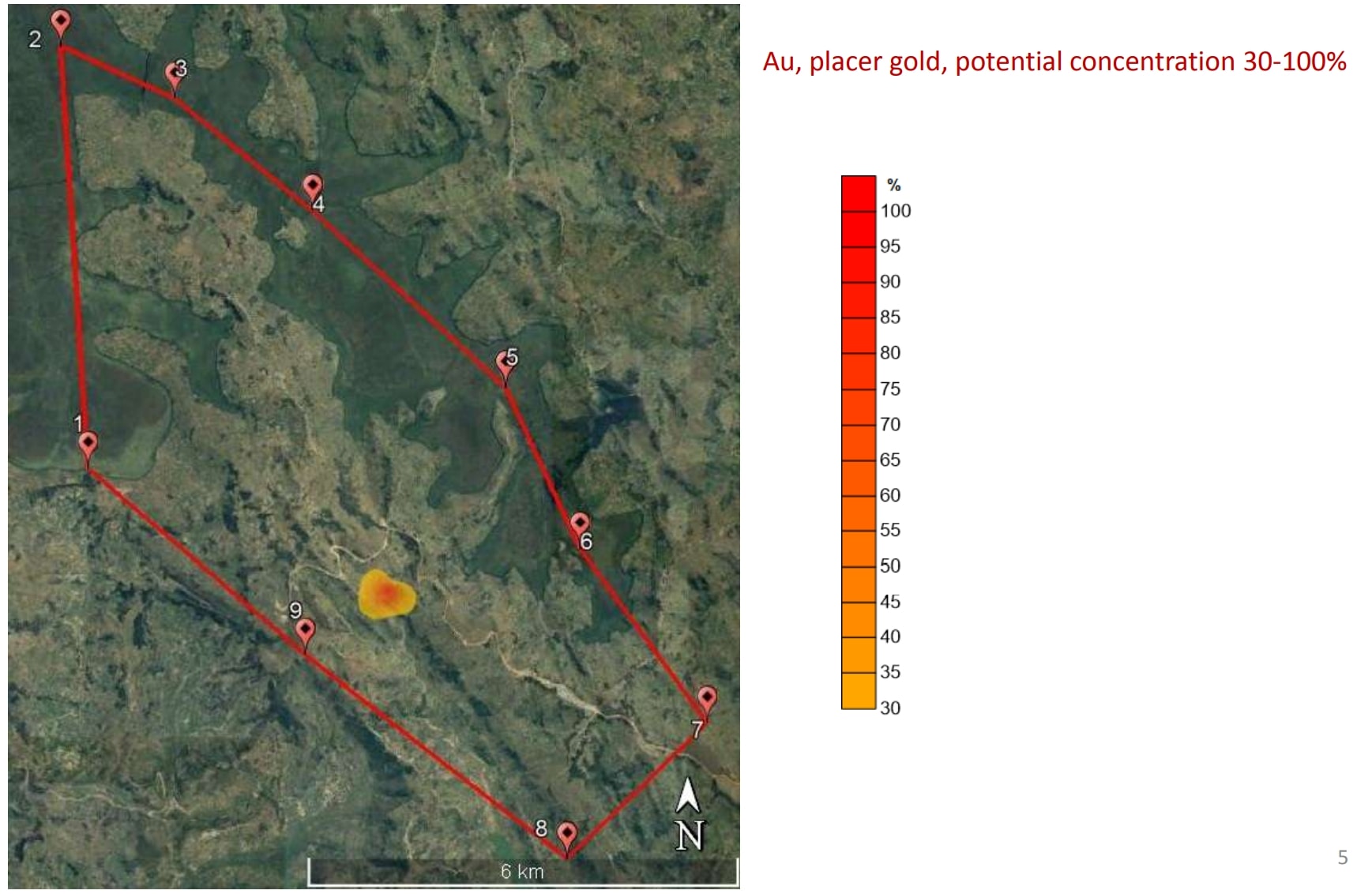
Creation of a 2D Model for Gold (Au) Deposits
This stage involves the development of a two-dimensional model to represent the distribution of gold (Au) deposits within the study area. By processing high-resolution satellite data and applying advanced multispectral and mathematical analysis, the model accurately visualizes the concentration of gold at the surface. This helps in identifying potential deposit locations.
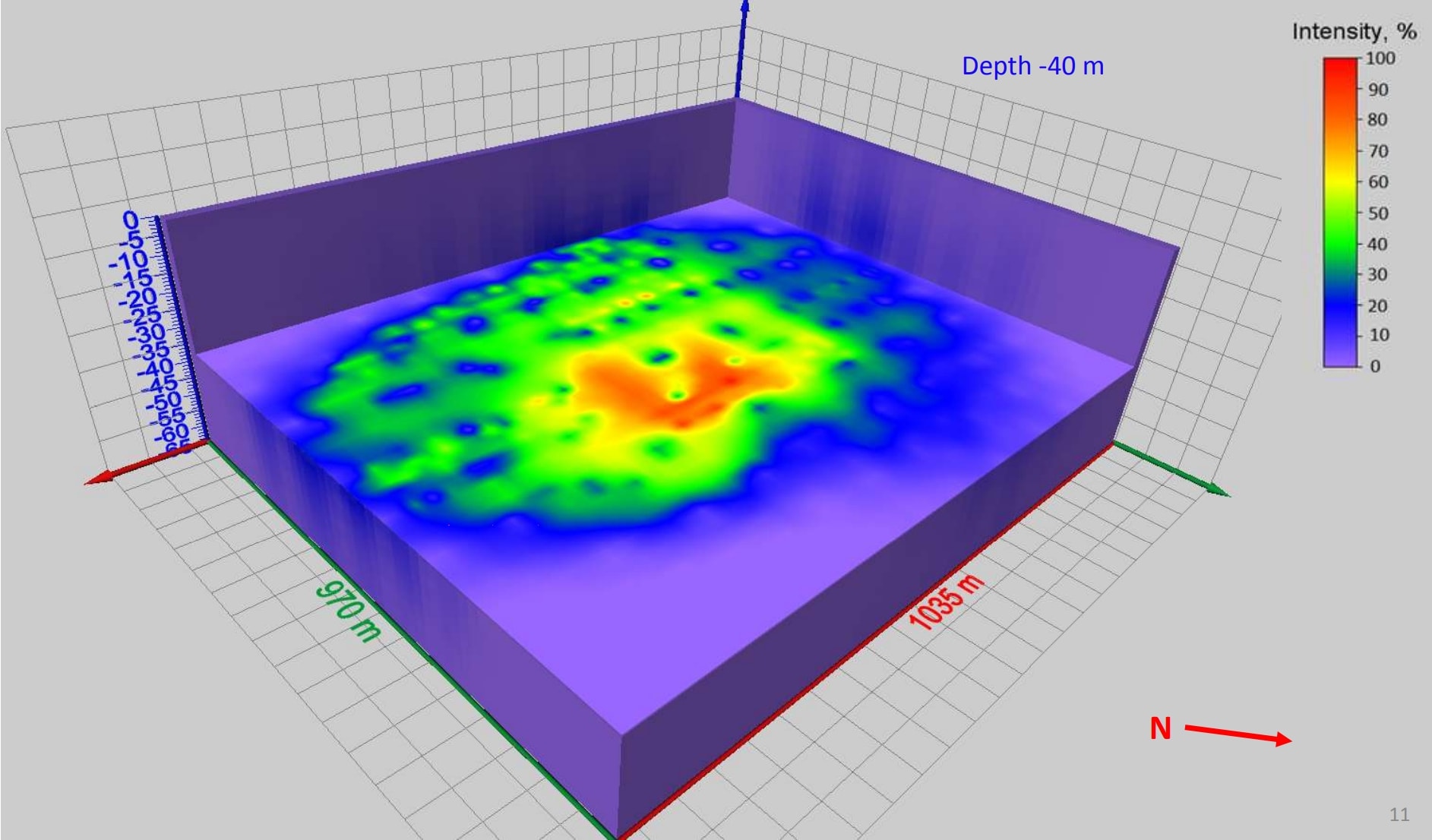
Creation of a 3D Block Model for Gold (Au) Deposits
This stage involves the development of a three-dimensional block model to represent the structure and concentration of gold (Au) deposits within the study area. By processing multispectral data and incorporating mathematical analyses, the model provides a volumetric visualization of the deposit, including depth and spatial distribution. This approach enables precise assessment of gold concentrations and aids in the efficient planning of exploration and extraction activities.
VMF Capabilities
Ore Volume Calculation
(in million m³)
Accurate estimation of the total volume of ore present within the deposit, providing a comprehensive assessment of the resource base.
Average Specific Content
(grams/ton)
Calculation of the average concentration of valuable elements within the ore, measured in grams per ton, to determine the quality of the deposit.
Volume of Ore Industrial Stock
Estimation of the volume of ore suitable for industrial extraction, aiding in the assessment of viable reserves for commercial exploitation.
Convertable Formats
VMF is fully compatible with various geological systems, including UTM (Universal Transverse Mercator) and Coral Draw, ensuring seamless integration and accurate data visualization. This compatibility enables efficient data exchange and enhances the precision of geological modeling and analysis.
VMF CAPABILITY
For Companies That Need Precise Results
For Companies That Need Precise Results
Contact our team to discuss your mineral survey requirements.
Get in Touch