
Evaluate the Potential of Your Deposit Before Drilling
VMF: Reliable Identification of Hydrocarbon Deposit Anomalies (Onshore and Offshore)
VMF technology accurately identifies hydrocarbon deposit anomalies, both onshore and offshore, providing detailed insights into their location, boundaries, and type (Oil, Gas, or Gas Condensate). It also determines the number of hydrocarbon-bearing horizons and their depths, ranging from just a few meters to 8 kilometers.
VMF measures the quantitative characteristics of hydrocarbon deposits, generates deposit cross-sections, highlights existing reserves, and pinpoints optimal drilling locations for exploration wells.
VMF can identify and map the following hydrocarbon types:
Stages of Research Using the VMF Methodology
Preliminary Study and Area Selection
Identification and assessment of the target study area based on geological and geospatial criteria.
Acquisition of High-Quality Satellite Data
Selection of high-resolution satellite digital imagery tailored to the geographical region of interest.
Digital Data Processing
Application of advanced data analysis techniques, including spinor, multispectral, and specialized mathematical analyses, alongside programming and computational processing of the acquired satellite materials.
Development of 2D Models
Creation of two-dimensional models illustrating the projected total concentrations of specified elements within the study area.
Construction of 3D Volumetric Models
Compilation of three-dimensional models to map the concentrations of targeted elements. The volumetric model is generated by processing data from frontal and angular geological surveys. Signal strength correlation coefficients are integrated to account for variations in depth, enabling precise determination of element concentrations at specific spatial coordinates. This approach provides an accurate volumetric estimation of hydrocarbon reserves within the geological block.
High-Speed Remote Detection of Oil and Gas Reserves
The VMF method offers a cutting-edge solution for identifying and delineating oil and gas fields by analyzing the total spectra of multiple primary hydrocarbon compounds. These spectra provide precise information on the location of hydrocarbon deposits.
With scanning capabilities ranging from just a few meters to depths of up to 8 kilometers, the VMF method leverages advanced scientific principles. It captures and processes direct spectral signals emitted by the elemental components of actual hydrocarbon deposits, ensuring accurate and reliable exploration results.
Strategic Advantages of VMF Technology
VMF enables the development of targeted strategies for petroleum resource exploration and utilization within specific regions. It provides critical insights into the valuation of concessions for purchase or sale, optimizing investment decisions. By significantly reducing non-productive drilling, VMF enhances the efficiency and cost-effectiveness of geological exploration.
PAST PROJECT SAMPLE
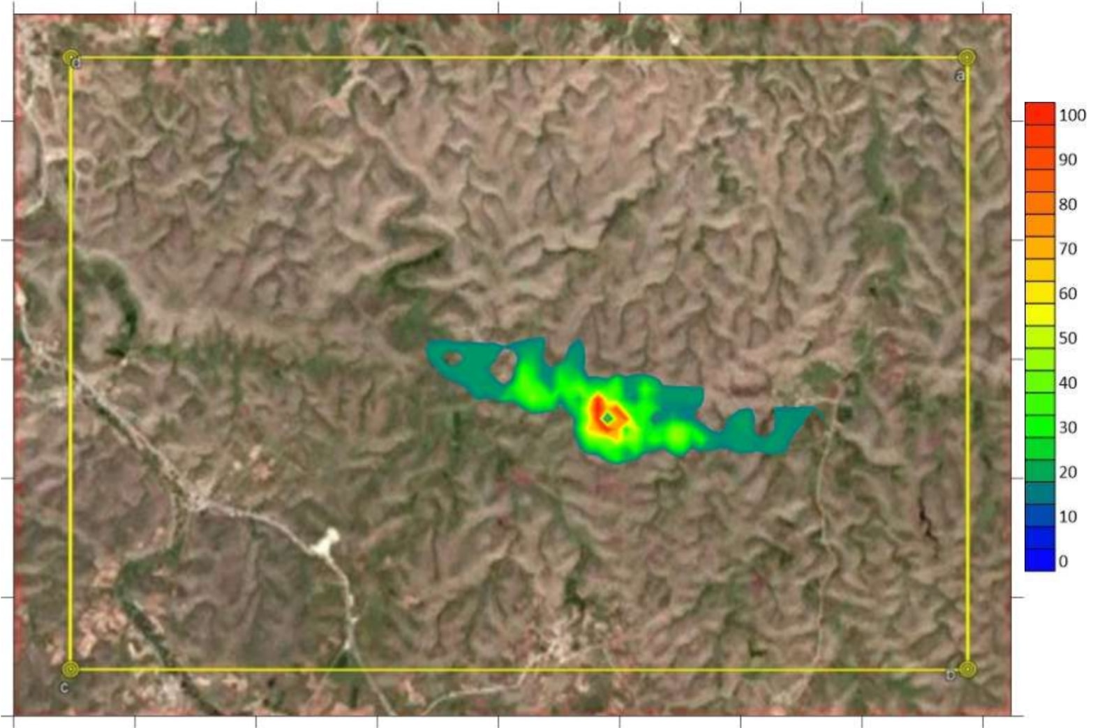
Creation of a 2D Model for Oil Deposits
This report presents the findings of scientific research conducted to identify potential oil accumulation points within the customer's licensed area. The research utilizes the VMF (Verification of Multispectral Forecast) analysis method, which combines advanced mathematical and multispectral techniques applied to satellite imagery. This approach enables the precise identification of oil deposits by analyzing the concentrations of key elements, including Carbon (C), Hydrogen (H), Sulfur (S), and Nitrogen (N).
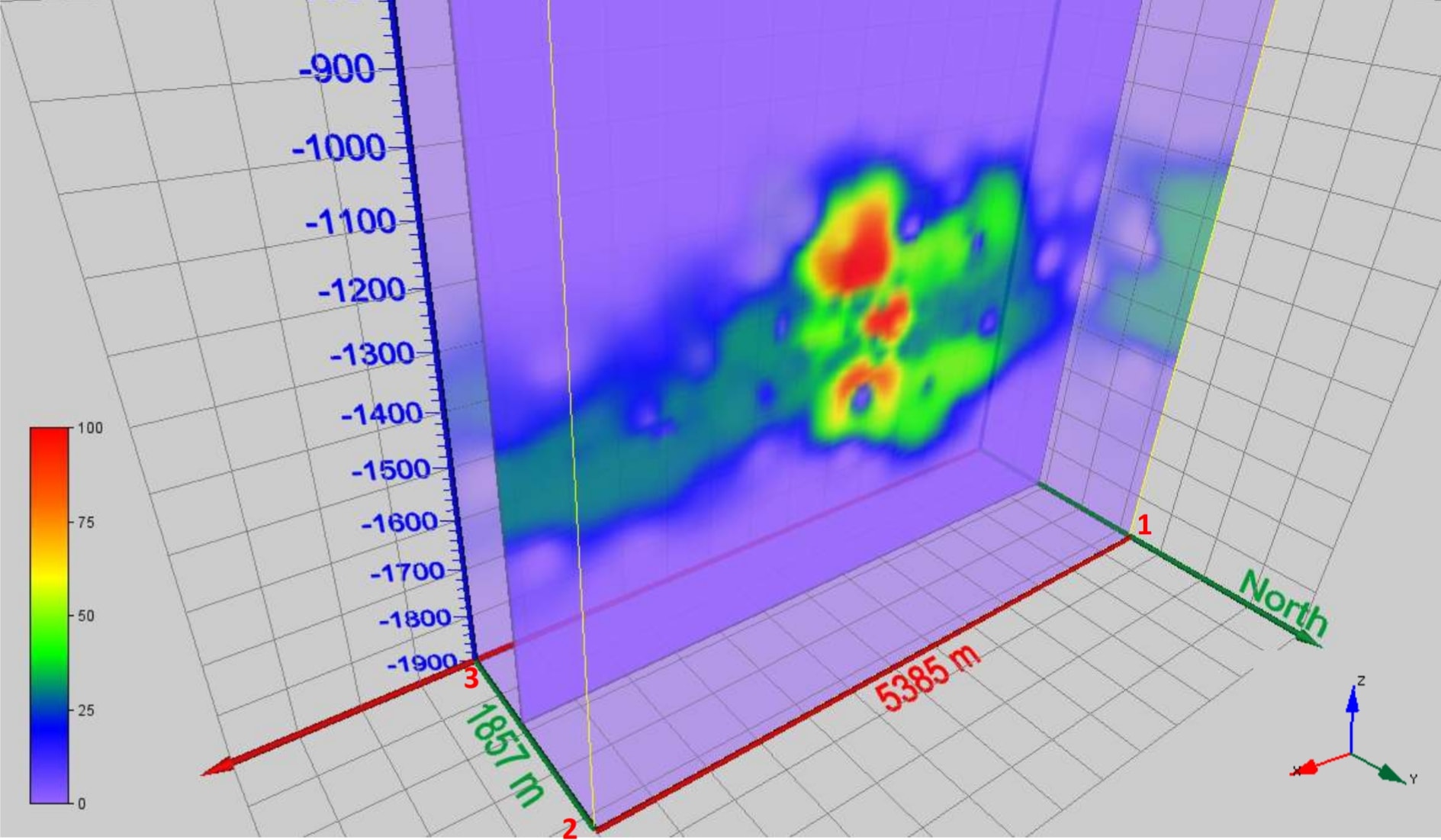
Creation of a 3D Block Model for Oil Deposits
This stage involves the development of a three-dimensional block model that accurately represents the oil deposit's structure and distribution. By processing multispectral satellite data and applying advanced mathematical analysis, the model provides a detailed volumetric visualization of the oil deposit. The 3D model allows for a more precise understanding of the deposit's spatial extent, depth, and concentration, enabling optimized exploration and resource management strategies.
VMF CAPABILITY
VMF: The Most Advanced Time-Saving and Cost-Effective Solution for Reserve Exploration
Ready to Explore?
Contact our team to discuss your survey requirements and receive a tailored proposal.
Get in Touch